hello!
just got access to a computer and thought I'd post another 'quickie' while i had the chance.
at his very moment, i am in mt cook natl park and it is MAGNIFICENT! the last two days were spent climbing the most scenic hike to the famous Mueller hut, high in a snowfield surrounded by glaciated peaks. for those two days, the weather was the clearest that this area has had in months, with unobstructed views throughout the park (ahh...my weather luck continues). it is very rare to see all of these peaks and especially mt cook because of the altitude, clouds, weather, etc. Mt Cook (or Aoraki is it's native Maori name, meaning "Cloud Pearcer") is the highest point in all of australasia, and 22 of the 27 highest peaks in NZ are in this park. the photos will be schweeeeeet, but it will be a few days before i can post any.
i am sitting in a small lodge about one mile from mt cook's little 'village' (which is a dead-end road consisting of a hotel, a few chalets, a cafe and a NZ park office). the lodge is owned/run by the NZ alpine club and right now there is NO ONE here. it is sooooo laid back, and reminds me of the movie 'the shining'. seriously!
the weather changed today big-time! it had been drizzling, then turned to rain, then buckets of rain, and now snow! the sound of it on the roof of this cavernous room is the only thing breaking the perfect silence. the DOC forcasts quite a bit of snow tonight (bizarre) then clearing tomorrow morning, so the entire park should be dusted in white...perfect for another day hike or two in this glorious valley amongst the mountain peaks.
ok. gotta go for now. heading outside to chop some wood to stoke the pot-bellied wood burning stove, 'cause there is no heat here. I'll be careful with that ax...ala "Heeeeeeere's Johnny!" haha
ps...someone left 5 cans of "Tasman Bitter" beer on the fridge shelf marked 'free'. yaahoo, an early xmas present.
Tuesday, December 19, 2006
Friday, December 15, 2006
Writers block!
I have writers block. Not that I don't know what to write, or don't have plenty to write about...but I keep getting "blocked" from the computer cafes by the constant interruption of actually DOING the things I plan on writing about.
So bear with me. However, I have posted new photos to the flickr site. All in reverse-chronological order.
Upcoming posts:
-The Milford Track (The finest tramp in all the world)
-Stewart Island (Muddy-mud-muckymud)
-Various quotes and poems
-Showering with two Isreali girls
-Fried eggs and red wine
-Everyone has a double (you wouldn't believe how many people you meet that remind you of someone you know)!
-The southeast coast into the Palatial retreat in Christchurch.
My travel partner left New Zealand a few days ago for Australia. So, I am once again on the solo trail. Have spent the last few days engaging in some much needed, major chillin' in Christchurch and recharging my inner-batteries. I plan to hit the road again tomorrow for Banks Peninsula (volcano), then south again toward Mt Cook, Wanaka, Rees Dart Trail, etc...not sure where I'll end up for Xmas and New Years.
Thanks for the emails and comments!! It is great to check my mailbox and receive emails from y'all. It makes 9200 miles disappear with a "click".
Thursday, November 30, 2006
The Routeburn and Caples Tracks
The next town in our venture south was Wanaka, a picturesque town situated on (naturally) Lake Wanaka. We relaxed for a few days and let the rain pass while making arrangements to hike the Routeburn and Caples Track.
The Routeburn is one of the most famous of New Zealands Great Walks. It is 40km long one-way trail that takes 3 days. We decided to intersect it with the Caples Track at the western trail head to double back and make it a loop (so that we could get back towards the car).
Knock on wood, but...the weather cleared up the day we started the track and was virtually perfect for the 5 days of this trek.
The first days hike is through native ferned forest, along a pristine river surrounded by mountains and up through the Routeburn Flats Valley then up, UP to the Routeburn Falls Hut. It is a 40 bed hut perched on the mountainside overlooking the valley, with two waterfalls behind it. I ate dinner (pasta, of course) then strolled behind the hut to a solitary rocky outcropping...with the falls in back of me, the entire valley stretched out in front and watched the sun go down as the stars came out, until it became too windy and cold.
Most folks roust about quite early in the morning on these hikes. One reason is that most folks go to bed early because, let's face it, there is not much to do in a rustic hut after the sun sets. Still, the 6AM sound of rustling backpacks, zip-lock baggies, stuffing sleeping bags, pots/pans, buckles, snaps, zips...enough! You might as well get up! Then, the mass gathering in the kitchen area to cook up some gruel or smear a bagel with peanut butter and Nutella, and cuddle up to a hot cup of tea. But here's the quizzical part to me: everyone packs up and departs from the hut immediately after. The ever-impressive DOC (dept of conservation), in an effort to maximize the enjoyment of the outdoor experience, spaces the huts between 5-8 hours hiking per day, so that you can leisurely make your way to the next hut, leaving time to (literally) smell the flowers, or "gawk n' awe" at the waterfalls/mountains/valleys/wildlife/scenery in general, take a few photos, find a perfect vista to sit down and enjoy a munchable snacky...and still make it to the next hut before sunset (and sunset isn't until 8:30 ish this time of year). Because, as mentioned earlier, there isn't much to do once you get to a hut. My discussions with several hut wardens revealed how they question the same thing. "People start showing up at the hut around noon (as if they won the race), then sit around the hut for 8 hours playing cards and waiting to cook dinner and go to bed!" My trail mode has remained consistent: I am generally the last to leave the hut (enjoying the sunrise and a cup o tea), thus giving me the feeling that I have the trail to myself (no one to bump into ahead and no one to see over my shoulder). My pace is slow and steady, my eyes are ever wandering side to side and in back to soak in the constantly changing views and sounds and smells around every nook and cranny. I would find it difficult to ingest what my senses were surrounded by if I past by any faster. After all, it's the journey, not the destination, right? I even made up a little poem about this while on the Milford Track. Kinda simple and silly (and subject to further editing), but...I call it Slowin' n Growin'
The older I get, the slower I walk.
The slower I walk, the more I see.
The more I see, the more I learn.
The more I learn, the more I grow.
(...and realize just how little I truly know)
Blah, blah...Anyway, I massively digress. So, I leave the hut and begin another perfect day of tramping up into the Hollyford mountains, through a cirqued valley of waterfalls and spring wildflowers, then surprised by the large alpine Lake Harris filled with snowmelt, then over a rocky-lipped pass and gently down to a small emergency shelter that was built on the other side. Some people from our group were resting there. Mac and I found a spot on the sunny, wind-less side and reclined on our packs as we grabbed the food bag to extract some muchies (cheese, meatstick, crackers, chocolate and an apple). A girl came along looking for a spot out of the wind and we invited her to join us. She had that intriguing French accent (rooowwl) and we made introductions and small talk. After chatting for awhile (your gonna love this)...she looked at us and asked "Zo, yoo are fazzer and zun?" haha we rolled with laughter. MacKenzie started calling "Hey dad" or "Old man". Yea, I know, teehee...no comments please. After our snack, we actually took a short nap and relaxed in the sun for over 2 hours. Hey, no hurry to get to the next hut, right? Oh, wait, actually we camped this night (it is much cheaper to tent than stay in the huts). The campsites were a few hundred meters from the hut in a nice field near the lake. The tenting crew tend to be a more rustic breed than the hut-only types. We all cooked noodles outside and bundled up because it gets COLD out there once the sun goes down. For the first time, my new little tent house me, 6'4" MacKenzie and both our packs. Tight but cozy.
The next morning, a helicopter landed at the hut. It was going to set dynamite charges to some snow and ice that built up on the mountainside above the trail that we hiked the previous day. It posed a small chance of avalanche. We watched as it took off, flew up the mountainside, hovered over the snow mass and BOOM! snow and ice went flying! They did it 3 times until most of the loose snow was clear. It was kinda exciting to see.
Without too many details, the next 3 days of the tramping were equally stupendous. Weather was good. Scenery spectacular. Challenging hiking up and down, but plenty of time each day to finish. Day three was a lengthy 9+ hour tramp. On day 4 and 5, we left the populated (40 people per day maximum) Routeburn track for the Caples return loop. The track was virtually deserted and it was much more un-maintained and muddy. The huts are smaller and less equipped, but sealed and a solid roof nonetheless. The sandflies can get pretty bad. Nasty little biting critters!
Ont he last day we underestimated the time to finish the track and had to literally run to the trail head to catch the shuttle that would take us back to our car. A quick 15 minute shuttle bus to an aqua taxi that took us across the lake in 20 bumpy minutes. Just as we got to the car, took off our boots and grabbed a box of Gingersnaps (yum) from the trunk...it started to rain. Perfect timing again! A twisted 30 minute drive brought us to Queenstown for long hot shower, huge gluttonous pizza, cold beer and soft bed. Those simple things are never taken for granted on the road...and they are always relished after a sweaty, exhausting, but incredibly rewarding sojourn into nature.
Speaking of which, the next day was Thanksgiving. A deserved day of rest as I prepared for New Zealand's most famous Great Walk, The Milford Track, in two days hence. I bought a bottle of local NZ red wine and had curried lamb with rice at a small Nepalese restaurant. With each bite, I thought of all the people I love and the things that I have to be thankful for...and realized what we all know, and try not to forget...that everyday is Thanksgiving Day!
**but, I admittedly missed the whole turkey, stuffing, mashed potato, gravy, gravy, gravy, corn, pie(s), Detroit football game thing**
Next post: The Milford Track!
P.S. Watched the movie "Crash" that night at the hostel. It is a good movie. Nominated for 6 Academy Awards and won 3 including best picture.
Another great movie I watched was "An Inconvenient Truth". It should be mandatory viewing. Then ignorance (ie. lack of knowledge about) would not be an excuse.
The Routeburn is one of the most famous of New Zealands Great Walks. It is 40km long one-way trail that takes 3 days. We decided to intersect it with the Caples Track at the western trail head to double back and make it a loop (so that we could get back towards the car).
Knock on wood, but...the weather cleared up the day we started the track and was virtually perfect for the 5 days of this trek.
The first days hike is through native ferned forest, along a pristine river surrounded by mountains and up through the Routeburn Flats Valley then up, UP to the Routeburn Falls Hut. It is a 40 bed hut perched on the mountainside overlooking the valley,
 with two waterfalls behind it. I ate dinner (pasta, of course) then strolled behind the hut to a solitary rocky outcropping...with the falls in back of me, the entire valley stretched out in front and watched the sun go down as the stars came out, until it became too windy and cold.
Most folks roust about quite early in the morning on these hikes. One reason is that most folks go to bed early because, let's face it, there is not much to do in a rustic hut after the sun sets. Still, the 6AM sound of rustling backpacks, zip-lock baggies, stuffing sleeping bags, pots/pans, buckles, snaps, zips...enough! You might as well get up! Then, the mass gathering in the kitchen area to cook up some gruel or smear a bagel with peanut butter and Nutella, and cuddle up to a hot cup of tea. But here's the quizzical part to me: everyone packs up and departs from the hut immediately after. The ever-impressive DOC (dept of conservation), in an effort to maximize the enjoyment of the outdoor experience, spaces the huts between 5-8 hours hiking per day, so that you can leisurely make your way to the next hut, leaving time to (literally) smell the flowers, or "gawk n' awe" at the waterfalls/mountains/valleys/wildlife/scenery in general, take a few photos, find a perfect vista to sit down and enjoy a munchable snacky...and still make it to the next hut before sunset (and sunset isn't until 8:30 ish this time of year). Because, as mentioned earlier, there isn't much to do once you get to a hut. My discussions with several hut wardens revealed how they question the same thing. "People start showing up at the hut around noon (as if they won the race), then sit around the hut for 8 hours playing cards and waiting to cook dinner and go to bed!" My trail mode has remained consistent: I am generally the last to leave the hut (enjoying the sunrise and a cup o tea), thus giving me the feeling that I have the trail to myself (no one
 to bump into ahead and no one to see over my shoulder). My pace is slow and steady, my eyes are ever wandering side to side and in back to soak in the constantly changing views and sounds and smells around every nook and cranny. I would find it difficult to ingest what my senses were surrounded by if I past by any faster. After all, it's the journey, not the destination, right? I even made up a little poem about this while on the Milford Track. Kinda simple and silly (and subject to further editing), but...I call it Slowin' n Growin'
The older I get, the slower I walk.
The slower I walk, the more I see.
The more I see, the more I learn.
The more I learn, the more I grow.
(...and realize just how little I truly know)
Blah, blah...Anyway, I massively digress. So, I leave the hut and begin another perfect day of tramping up into the Hollyford mountains, through a cirqued valley of waterfalls and spring wildflowers, then surprised by the large alpine Lake Harris filled with snowmelt, then over a rocky-lipped pass and gently down to a small emergency shelter that was built on the other side. Some people from our group were resting there. Mac and I found a spot on the sunny, wind-less side and reclined on our packs as we grabbed the food bag to extract some muchies (cheese, meatstick, crackers, chocolate and an apple). A girl came along looking for a spot out of the wind and we invited her to join us. She had that intriguing French accent (rooowwl) and we made introductions and small talk. After chatting for awhile (your gonna love this)...she looked at us and asked "Zo, yoo are fazzer and zun?" haha we rolled with laughter. MacKenzie started calling "Hey dad" or "Old man". Yea, I know, teehee...no comments please. After our snack, we actually took a short nap and relaxed in the sun for over 2 hours. Hey, no hurry to get to the next hut, right? Oh, wait, actually we camped this night (it is much cheaper to tent than stay in the huts). The campsites were a few hundred meters from the hut in a nice field near the lake. The tenting crew tend to be a more rustic breed than the hut-only types. We all cooked noodles outside and bundled up because it gets COLD out there once the sun goes down. For the first time, my new little tent house me, 6'4" MacKenzie and both our packs. Tight but cozy.
The next morning, a helicopter landed at the hut. It was going to set dynamite charges to some snow and ice that built up on the mountainside above the trail that we hiked the previous day. It posed a small chance of avalanche. We watched as it took off, flew up the mountainside, hovered over the snow mass and BOOM! snow and ice went flying! They did it 3 times until most of the loose snow was clear. It was kinda exciting to see.
Without too many details, the next 3 days of the tramping were equally stupendous. Weather was good. Scenery spectacular. Challenging hiking up and down, but plenty of time each day to finish. Day three was a lengthy 9+ hour tramp. On day 4 and 5, we left the populated (40 people per day maximum) Routeburn track for the Caples return loop. The track was virtually deserted and it was much more un-maintained and muddy. The huts are smaller and less equipped, but sealed and a solid roof nonetheless. The sandflies can get pretty bad. Nasty little biting critters!
Ont he last day we underestimated the time to finish the track and had to literally run to the trail head to catch the shuttle that would take us back to our car. A quick 15 minute shuttle bus to an aqua taxi that took us across the lake in 20 bumpy minutes. Just as we got to the car, took off our boots and grabbed a box of Gingersnaps (yum) from the trunk...it started to rain. Perfect timing again! A twisted 30 minute drive brought us to Queenstown for long hot shower, huge gluttonous pizza, cold beer and soft bed. Those simple things are never taken for granted on the road...and they are always relished after a sweaty, exhausting, but incredibly rewarding sojourn into nature.
Speaking of which, the next day was Thanksgiving. A deserved day of rest as I prepared for New Zealand's most famous Great Walk, The Milford Track, in two days hence. I bought a bottle of local NZ red wine and had curried lamb with rice at a small Nepalese restaurant. With each bite, I thought of all the people I love and the things that I have to be thankful for...and realized what we all know, and try not to forget...that everyday is Thanksgiving Day!
**but, I admittedly missed the whole turkey, stuffing, mashed potato, gravy, gravy, gravy, corn, pie(s), Detroit football game thing**
Next post: The Milford Track!
P.S. Watched the movie "Crash" that night at the hostel. It is a good movie. Nominated for 6 Academy Awards and won 3 including best picture.
Another great movie I watched was "An Inconvenient Truth". It should be mandatory viewing. Then ignorance (ie. lack of knowledge about) would not be an excuse.
Letter from the Editor
It has been brought to my attention that too many exclamation points are being used on this blog. In an effort to save cyber exclamation points, but still have the same impact to the blogs content, the following new rules will apply:
When you see a period at the end of a sentence, it is actually an exclamation point.
When you see an exclamation point at the end of a sentence, add two more exclamation points!
Thank you.
When you see a period at the end of a sentence, it is actually an exclamation point.
When you see an exclamation point at the end of a sentence, add two more exclamation points!
Thank you.
Wednesday, November 29, 2006
"Random Thoughts" in New Zealand
New things I've noticed as a traveler in this foreign land:
-Driving on the right side of the car and the left hand side of the road takes some getting used to. But you do get used to it. But the turnabouts instead of stop lights are still tricky.
- This extends to walking on the sidewalk or passing someone on the steps (you generally walk on the left).
-People stop at the crosswalks when the light is red...and wait there until the signal to cross the street. There is a clear signal at each crosswalks and drivers respect the pedestrian rule (and vice-versa).
-New Zealand currency is waterproof!! (Believe me, it makes sense).
-Most buildings have motion sensor lighting. If no one is in the room, the light is off. When you walk into a room, the light turns on. (WOW, what a concept to save electricity, money and waste!) Likewise with paper towels. Most places have air dryers. I know, I know, I hate those things too. But these sonofaguns BLOW and your done.
-One more bathroom thing. The toilets all have two flush buttons, half flush and full flush (bear with me here): One is for #1 and two is for #2
-Speaking of waste: recycling bins are everywhere! It is just a part of life. I guess when you are a small, self-contained island country, there are not as many places to keep dumping garbage into landfills. (and it makes sense as well).
-"Tilley Brand" hats are worth the money.
-The metric system makes SO MUCH SENSE. Imagine an entire system (weights, distance, measures, temperature) all based on 10's. It's actually very easy.
-Many of the towns (large and small) have a roof built over the entire length of the sidewalk. HOW COOL! People can still stroll around town even in the drizzle.
-Nutella "hazelnut chocolate spread" is the universal backpackers staple food.
-There are more people from Germany traveling here than from any other nation.
-Most Americans that I have met are from Oregon, Washington or 'Minnesota'?
-Light switches are down for 'ON' and up for 'OFF'. Hmmm...
-Many sinks have the two spigot system with hot on the right and cold on the left. I don't dig the two spigot thing...you can't run 'warm' water.
-Travelers tend to be veracious readers, well versed, and deep thinkers.
-Irish Pubs are ubiquitous.
-Throughout New Zealand, their national rugby team "The All Blacks" RULE!! It's fanatical. They make football fans look like...?
--Funny story. Three guys were talking at a pub about American Football. "American football has three teams...the offense, the defense, and the speciality team..and they just play once then trot off the field after dancing. The other two teams only play half the game!" It was funny to hear and watch. You see, in rugby, they play the ENTIRE game, and with NO protective gear! (and no dancing. haha)
I'll keep updating this post as new 'random thoughts' present themselves.
Thursday, November 23, 2006
The Wiley, Windy, West Coast
We left sleepy little Takaka town to head further down the west coast toward the small town of Hokitika via the Pancake Rocks of Potikiki. Picked up a hitcher from Ireland named Milo. These world travelers are so unique. They all have a special story to share (and if you listen closely enough, there is always something to learn). Milo has traveled quite extensively and said that "Traveling tends to lead to more questions than answers". Which is interesting since many people travel to answer some question...
The west coast is impressively stark and rugged, compared to the green hills and beaches of the east coast. The weather comes in from the Tasman Sea and mercilessly beats on the coast.
The potikiki Pancake Rocks are formations that stack up due to erosion. There are also blowholes that shoot up walls of water at high tide. It was a short side trip.
The days drive was 5-6 hours total and again very twisty and windy. It rained like crazy for short spells. We found a nice house-hostel to stay at in Hokitika.
The next morning, back in the car toward Arthur's Pass, the highest altitude town in NZ and the gateway to the Southern Alps and glaciers. We figured it would be a good place for a few day hikes before venturing further south.
We drove directly to the DOC office to inquire about hiking opportunities. We were impressed (but not surprised) to hear that the rains we drove through the day before were part of the largest rainfall at Arthur's Pass. It rained almost 15 inches in 3 hours! The banks of the river started to overflow and they were close to evacuating the town. Everyone whole town was on notice. We could see the aftermath and bulldozers were rebuilding the walls of the riverbank. WOW!! The main day hike to Avalanche Peak was not recommended because parts of the trail had washed away. We chose another spectacular hike called the Bealy Spur, that overlooked the mountain range. The next day we started to hike up the steep trail to the Avalanche Peak to see how far we could get. Once we climbed above the bush line to the open rocks, the wind picked up and clouds started rolling in. The winds were the strongest than I have ever experienced in my life! I was on my hands and knees to take a few pictures. Mackenzie was blown backwards into some bushes. We looked at each other and pointed "Down Now!" We boogied down that hill and back to the car before the rain started.
Our goal was to find a hidden hot spring and take a dip after spending the day in the cold wind and rain. After following the directions we were given and trying several times for 90 minutes to find the springs (which were located along a remote river bank), we gave up before sunset. We found out later that, because of the heavy rains, the river had risen too high and covered the place were the hot spring would have met the river. Arrghhh...
We started driving toward the Franz Joseph Glacier for the night. The rain never let up and the next morning it was coming down in buckets. It was expected to rain the next few days (typical) so we decided to drive further south toward Wanaka, where we would plan the big hikes of the Otago Peninsula and Fiordland regions.
The West Coast of New Zealand is everything they say it is...a rugged, salt-sprayed stretch of wild rocky beaches, cliffs and bush-clad hills sweeping up toward towering icy peaks. Easy access to solitude is a major characteristic--a short plunge off either side of the highway, and you can be enveloped in rainforest, or skipping pebbles on a wind-swept beach, or tramping past a snow-clad silhouette of a serene mountainous lake.
Wednesday, November 22, 2006
Life's A Beach! (On the Abel Tasman Coastal Track)
The Abel Tasman Coastal Tramp is a 51km track and one of the most beautiful in the Country, passing through pleasant native bush that overlooks numerous beaches of golden sand lapped by gleaming blue-green water. The numerous bays, beaches and overlooks are like a travel brochure come to life!
Awoke at 6:30 AM in Nelson to drive to the Kayak Company. We decided to rent kayaks for two days and would hike the remainder of the track for another two days to it's Northern Terminus.
Again, the weather goddess smiled upon us. It has been incredible. The kayak company gives you a lesson, all equipment needed (including bilge pump and signal flair), and arra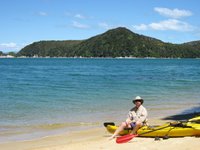 nges to pick up the kayak at a predetermined beach further up the coast.
We paddled for hours along the serene coast, observing birds and rock formations and small beaches along the coast. A few seals swam with mackenzie for awhile. We arrived at the campsite on Te Pukatea beach, a massive sheltered "C" shaped beach cove nestled among the trees. There are 8 campsites there. We cooked some noodles and sat on the beach and watched the sun set as the tide went out. Quiet, peaceful, mesmerizing, solitude, idyllic...ahhhhh. Simultaneously and almost imperceptibly (is that a word?), the stars began to pop out and flicker quickly. Before night was done, the sky was FILLED with stars. The heat rising from the earth made them twinkle constantly. However, I could not recognize the Southern Sky constellations, then, coming up on the horizon, I saw the ever-familiar Orion. But, he was upside down!! In a short time, I saw 5 satellites and a shooting star.
Awoke at 6:30 AM in Nelson to drive to the Kayak Company. We decided to rent kayaks for two days and would hike the remainder of the track for another two days to it's Northern Terminus.
Again, the weather goddess smiled upon us. It has been incredible. The kayak company gives you a lesson, all equipment needed (including bilge pump and signal flair), and arra
 nges to pick up the kayak at a predetermined beach further up the coast.
 We paddled for hours along the serene coast, observing birds and rock formations and small beaches along the coast. A few seals swam with mackenzie for awhile. We arrived at the campsite on Te Pukatea beach, a massive sheltered "C" shaped beach cove nestled among the trees. There are 8 campsites there. We cooked some noodles and sat on the beach and watched the sun set as the tide went out. Quiet, peaceful, mesmerizing, solitude, idyllic...ahhhhh. Simultaneously and almost imperceptibly (is that a word?), the stars began to pop out and flicker quickly. Before night was done, the sky was FILLED with stars. The heat rising from the earth made them twinkle constantly. However, I could not recognize the Southern Sky constellations, then, coming up on the horizon, I saw the ever-familiar Orion. But, he was upside down!! In a short time, I saw 5 satellites and a shooting star.
Pre-dawn the next morning, the forest was loudly echoing with the chattering calls of many types of birds. I couldn't sleep, but enjoyed laying in my tent surrounded by the enchantingly lovely sounds of my winged friends.
Another picture perfect weather day. After a quick bagel, we packed and jumped back in the kayaks for more northern paddlin'. We stopped at two beaches to chill and relax before our final approach to the drop off point at Onetahuti Beach. We looked out to sea a bit and noticed white-tipped waves and that the winds had picked up considerably around the exposed point of the cliffs that we had to paddle along. We battened down the hatches and figured we better hit it before it got worse. Once we passed the secure arms of the cove, the winds along the rugged coast hit us like a ton of bricks! No choice but to paddle as hard as possible directly into the waves and winds. Sometimes you would look over at the shore and see that you were going nowhere, but you had to paddle just to stop from going backwards or capsizing. It seemed like we were battling the winds and waves for hours. Sea spray pelted our faces and the waves were crashing right into us and tossing our kayaks around. At times I thought my arms would give out. Eventually, we made it around the horn and into the next bay called Onetahuti Beach; where the kayaks would be picked up, we would camp tonight and start hiking from tomorrow.
 the next bay called Onetahuti Beach; where the kayaks would be picked up, we would camp tonight and start hiking from tomorrow.
Deja Vu on the camping thing...set up tent, ate noodles, watched the sunset and stars come out..blah, blah, same old, same old.
P.S...The cliff face we had to paddle around is called "Cape Foul Wind"or something (hmmmm..)
We met a girl named Heather from Seattle the night before and she was camping at our beach again tonight. We all talked about hiking together the next 2 days, then she would join our merry fellowship for a ride down the west coast since that was her intention also.
It rained off and on most of the night but by morning it had stopped and the sun shown again. So, we packed up and pushed on north toward the Anapai Bay campsite. The hiking here is so pleasant. In and out of forests with ferns and moss, then to a vista overlooking the next beach you would be walking on 10 minutes later, etc, etc. We arrived at Anapai Beach and had it all to ourselves! It was surreal. You almost felt as if you discovered a new land. I practiced cartwheels and handstands on the beach. We were all pretty silly (dance like no one is watching, right?).
Anyway, the next day was highlighted by reaching the northern tip of the coast at Separation Point, and area where Blue Penguins, Seals and Seagulls hang out. Took some pictures and checked out the funky looking penguins, but gale force winds picked up and we skedaddled for the protection of the forest. An hour later, we were at the car (picked up a hitcher from Holland) and driving toward a little (little) town of Takaka for a hot shower, hot meal and non-ground bed.
The Abel Tasman Coastal Track was truly a treat (unless you don't like beaches, coves, blue water, forests of ferns, birds, waterfalls...)
Saturday, November 18, 2006
Ferry thee well North Island
To travel from the North Island to the South Island, there is a 2.5 hour ferry ride that takes you throught the Cook Straight. Decided to buy a bottle of local red wine for the trip (hey, why not? Wine here is inexpensive and supports the local economy). It's a scenic ferry ride and the weather was perfect for it (although it gets incredibly windy through the straight). In fact, Wellington is named "Windy Welly" by the locals. 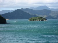 You never lose site of either island because they are quite close together. Entering the South Islands throught the Marlborough Sounds is beautiful. It's a series of small islands, cliffs and rolling green hills that the boat navigates through. You arrive in Picton (a small fishing village).
 You never lose site of either island because they are quite close together. Entering the South Islands throught the Marlborough Sounds is beautiful. It's a series of small islands, cliffs and rolling green hills that the boat navigates through. You arrive in Picton (a small fishing village).
 The map showed two routes to get to the next town of Nelson; one goes straight across and the other takes the inland 'highway' and around. We decided to attempt the straight across (shortest distance, right?). It was an incredibly windy road that went up and down along this sheer cliff! MacKenzie was driving since I had been enjoying the wine on the boat.  It probably took about the same time as the highway but it was much more scenic. It was low tide for the drive. The bays were all muddy and the boats were dry-docked in the mud. It was cool to see.
 It probably took about the same time as the highway but it was much more scenic. It was low tide for the drive. The bays were all muddy and the boats were dry-docked in the mud. It was cool to see.
We arrived in Nelson and checked into a hostel that we read about called "The Palace Hostel". It is a huge old Victorian house perched on a hill overlooking the small town. Very funky inside, with artwork, antiques, books and painted with bright colors. Sort of like an old hippy commune (which is how Nelson is sometimes described).  One of the guests staying there was walking the shore at low tide and came upon these HUGE mussels (6-7 inches)! He called them 'prehistoric' and the sweetest he had ever tasted. We built a fire in the outside BBQ and roasted them. Delish!
 One of the guests staying there was walking the shore at low tide and came upon these HUGE mussels (6-7 inches)! He called them 'prehistoric' and the sweetest he had ever tasted. We built a fire in the outside BBQ and roasted them. Delish!
We walked to the DOC (Dept of Conservation) office and made our booking for the Abel Tasman Coastal Track...starting tomorrow morning...
Sunday, November 05, 2006
Tramping around Mordor & Mount Doom. (Oh yeah...and I bought a car)
Change of plans since last post... (which has become part of the "plan").
Instead of heading north to the tip of the island...
I met a guy from canada and we pitched in to buy a car (it's a very common practice here and easy to buy/sell) and a more flexible way to get around than busses/shuttles/tour bus/etc. It's a 1993 toyota camry, seems to be in pretty good shape and only costs us about $1035 USD. I will re-sell it once I've completed the NZ Islands.
We headed southeast to the Coromandel peninsula (I keep calling it Coriander) and hiked about the Pinnacle Peaks area (In New Zealand hiking is called "Tramping"). It was a beautiful day and I got a bit of sunburn (oh woe is me!). We helped the hut warden erect a TV antenna at his little hut so that he could barely pick up 2 stations on his 6" screen. To thank us, he made a french press of Italian coffee. I visited him that evening and we sat and drank some of his homebrewed beer that he called "Pinnacle Piss" (aptly named!) But it hit the spot and he was an interesting character...a 65 year old Maori native that has been manning the hut for 6 years. He works 8 days on, then 8 days off. His name is Charles and I posted his pix on the website.
Then turned further south to the thermal activity area around the town of Rotorua (famous for geysers, mud pots and Maori cultural area). The Maori are the indigenous tribes of New Zealand. During the Maori welcoming ceremony for our group, I was made the ceremonial Chief and had to offer a green fern of peace to the challenging tribe before they would welcome us into their house for a celebration. It was thrilling! My friend took a picture and it is on the Flickr website.
Spent one night in town of Taupo, site of NZ's largest lake which was formed from a HUGE explosion. It blew a hole 606 cubic kilometers big!! By comparison, Mount Saint Helen's was only 3 cubic kilometers. It's massive and home to some of the largest trout in the world!
We then ventured further south to the Tongariro national park (a World Heritage Area) to tramp the 3 night northern circuit around some awesome active volcanic peaks!! This is one of the areas where Lord of the Rings was filmed. It was the inspriration for Mordor and Mount Doom! Pretty otherworldly!
  Check out the pictures!
New Zealand has an incredible system of backcountry huts that you can stay in when hiking the national parks (although you can tent as well). They help limit the impact on the fragile environment as well as offer an option to those not quite up to 'roughing it' in a tent. They range from$7-20 per night and have bunks, running water (from a rain collection system) and gas burners for cooking. Awesome! We've met families with small kids, and many older hikers as well (older as in 60's and 70's). There are such an inspiration and have so many stories to share! It's funny when you're trudging along with your pack on an 8 hour sweaty, mountainous hike all day...then you arrive at a hut to find some couples in their 70's sipping tea and greeting you "'ello mates!"
I am currently in wellington (NZ Capital) in the southernmost coastal town of the north island. It is a cool, kinda artsy, trendy town with many art museums and restaurants (especially the Oriental establishments serving the huge plates of noodles/rice for $5) Yum!!
The hostels (so far) are incredibly clean, well run, accomidating and fairly inexpensive (average $13-16). The kitchen area is a focal point and many people congregate to cook their own meals and meet people/share stories. What great comradery these travelers have! Most hostels have laundry, kitchen, internet, tv room, book swap, ride boards, and will help you with booking your travel plans.
So, in a nutshell: all is well...or as they say here "Sweet as!" It's their way of saying 'that's cool' or 'all good'
Lots to post but short on time, so....
check out some of the pix I've download to the My Flickr Photos. Look on the right under the "Links" menu.
http://www.flickr.com/photos/ubinger/
cheers mates!
Instead of heading north to the tip of the island...
I met a guy from canada and we pitched in to buy a car (it's a very common practice here and easy to buy/sell) and a more flexible way to get around than busses/shuttles/tour bus/etc. It's a 1993 toyota camry, seems to be in pretty good shape and only costs us about $1035 USD. I will re-sell it once I've completed the NZ Islands.
We headed southeast to the
 Coromandel peninsula (I keep calling it Coriander) and hiked about the Pinnacle Peaks area (In New Zealand hiking is called "Tramping"). It was a beautiful day and I got a bit of sunburn (oh woe is me!). We helped the hut warden erect a TV antenna at his little hut so that he could barely pick up 2 stations on his 6" screen. To thank us, he made a french press of Italian coffee. I visited him that evening and we sat and drank some of his homebrewed beer that he called "Pinnacle Piss" (aptly named!) But it hit the spot and he was an interesting character...a 65 year old Maori native that has been manning the hut for 6 years. He works 8 days on, then 8 days off. His name is Charles and I posted his pix on the website.
Then turned further south to the thermal activity area around the town of Rotorua
 (famous for geysers, mud pots and Maori cultural area). The Maori are the indigenous tribes of New Zealand. During the Maori welcoming ceremony for our group, I was made the ceremonial Chief and had to offer a green fern of peace to the challenging tribe before they would welcome us into their house for a celebration. It was thrilling! My friend took a picture and it is on the Flickr website.
Spent one night in town of Taupo, site of NZ's largest lake which was formed from a HUGE explosion. It blew a hole 606 cubic kilometers big!! By comparison, Mount Saint Helen's was only 3 cubic kilometers. It's massive and home to some of the largest trout in the world!
We then ventured further south to the
 Tongariro national park (a World Heritage Area) to tramp the 3 night northern circuit around some awesome active volcanic peaks!! This is one of the areas where Lord of the Rings was filmed. It was the inspriration for Mordor and Mount Doom! Pretty otherworldly!
  Check out the pictures!
New Zealand has an incredible system of backcountry huts that you can stay in when hiking the national parks (although you can tent as well). They help limit the impact on the fragile environment as well as offer an option to those not quite up to 'roughing it' in a tent. They range from$7-20 per night and have bunks, running water (from a rain collection system) and gas burners for cooking. Awesome! We've met families with small kids, and many older hikers as well (older as in 60's and 70's). There are such an inspiration and have so many stories to share! It's funny when you're trudging along with your pack on an 8 hour sweaty, mountainous hike all day...then you arrive at a hut to find some couples in their 70's sipping tea and greeting you "'ello mates!"
I am currently in wellington (NZ Capital) in the southernmost coastal town of the north island. It is a cool, kinda artsy, trendy town with many art museums and restaurants (especially the Oriental establishments serving the huge plates of noodles/rice for $5) Yum!!
The hostels (so far) are incredibly clean, well run, accomidating and fairly inexpensive (average $13-16). The kitchen area is a focal point and many people congregate to cook their own meals and meet people/share stories. What great comradery these travelers have! Most hostels have laundry, kitchen, internet, tv room, book swap, ride boards, and will help you with booking your travel plans.
So, in a nutshell: all is well...or as they say here "Sweet as!" It's their way of saying 'that's cool' or 'all good'
Lots to post but short on time, so....
check out some of the pix I've download to the My Flickr Photos. Look on the right under the "Links" menu.
http://www.flickr.com/photos/ubinger/
cheers mates!
Sunday, October 29, 2006
The Kiwi Has Landed!
Heeeeeey!
Just a quick post to let y'all know that i have arrived safely and am enjoying Auckland thus far. It's just another city, but it's clean, friendly and is beautifully flanked by the Tasman Sea on the west and the South Pacific Ocean on the east. Auckland is dubbed "The city of Sails" due to the many marinas. Weather has been pleasant; in the 60's and mild at night (and spring is well on it's way!) It is a very international city with a high Asian population, possibly due to the University of Auckland? With it comes a plethora of food options...and the competition is fierce (a huge plate of noodles or rice dishes cost about $4-5).
Tomorrow, I hope to head North to the "Bay of Islands" (how bad can that be?), then to the very tip-top of the North Island to an rugged, gnarled desolate tendril of earth called the Aupouri Peninsula. The west coast of this point is dominated and flanked by 90 mile beach (although it's only 64 miles long) which boasts huge sand dunes that you can slid down.
Will keep ya posted...
Tuesday, October 17, 2006
Ubie Bloggin'
Well, I finally got the "blog thing" up and runnin'. It will be an ongoing learning process, but I am pleased to have gotten this far. At least there is now a forum for me to keep a running diary of my experiences and whereabouts.
My blog's rules (so far):
Spelling and grammer do not count. The same goes for punctuation. This is intended to be a stream of consciousness diary of thoughts, memories, photos, etc. It will be created from various internet access points from all over the world when I can find them(which charge by the minute).
The top link on the right will take you to my Flickr blog site http://www.flickr.com/photos/ubinger/
Which is primarily used for posting photos. So, I intend on posting mostly verbage on this blog and linking the photos to the other. We'll see how that works...
Feel free to shoot me an email or post a comment. The miles between us can easily disappear with a click of the "Send" button.
Thursday, October 12, 2006
Mount Saint Helen's - Oregon

This pix was taken 3-4 miles from the volcano. Everything in every direction for miles around was destroyed from the blast in 1980 (26 years ago), and short growth is just starting to emerge from the ashy soil. They estimate the wind speed from the explosion to have been 600 MPH!
It is an eerie landscape.
Thursday, August 03, 2006
Friday, July 28, 2006


Subscribe to:
Comments (Atom)

